The 8th ISSMGE TC304/TC309 Student Contest
.png) |
Introduction |
Numerous landslides may be triggered by a major rainstorm or a strong earthquake in a short time. Rapid detection of these post-event landslides is very important for landslide risk management, particularly for consequence evaluation and emergency rescue. Landslide detection formerly relied on geological field surveys and is now mainly achieved through the visual interpretation of remote sensing images from satellites or unmanned aerial vehicles (UAV). This is still labor-intensive and time-consuming, especially when a large area is covered. With the rapid development of machine learning techniques, many deep learning algorithms (Fu et al., 2022; Ghorbanzadeh et al., 2022; Meena et al., 2022; Shi et al., 2020; Su et al., 2021), such as the convolutional neural network (CNN), have been applied to landslide detection. However, most previous studies treated landslide detection as a semantic segmentation task (i.e., identifying landslides and non-landslides), rather than an instance segmentation task (i.e., differentiating between different landslide objects). For example, Mask R-CNN (He et al., 2018) is a widely-used instance segmentation method. In order to create a landslide inventory for subsequent landslide studies such as landslide susceptibility mapping and forecasting, it is important to differentiate between different landslide objects to calculate respective covering areas, runout paths, and other properties.
This machine learning competition focuses on landslide detection. It is organized as the 8th ISSMGE TC304/TC309 Student Contest event at the 2nd Workshop on Future of Machine Learning in Geotechnics (2FOMLIG) held at Chengdu, China, October 11-13, 2024 (https://www.fomlig2024.com/). The contest will last three months. Students are invited to form teams to take part in the competition. The results should be submitted as an extended abstract through the conference website and presented at the conference, both in English. The three best teams, selected by the Contest Organization Committee, will be announced at the conference banquet.
 |
Problem description |
The purpose of this Student Contest is to develop machine learning models to identify landslides from satellite imagery. A training dataset and a testing dataset are provided, both including a satellite image, a pre-labeled landslide mask, and a digital terrain model (DTM). The training and testing images contain 131 and 28 landslides, respectively. Two tasks are included:
- The first task is to develop machine learning models to identify landslide instances. Transfer learning from a pre-trained landslide detection model is NOT allowed but it is allowed to use other generalized source models. The teams can (i) apply semantic segmentation algorithms first and then differentiate between landslide instances in another step; or (ii) directly perform instance segmentation in one step. It is encouraged to use DTM information to distinguish landslides from similar objects, such as roads and buildings.
- The second task is to propose probabilistic methods to quantify the uncertainty of the detected landslide areas or boundaries. The teams should bear in mind that the provided landslide masks do not represent accurate ground truth of landslides (i.e., “imperfect labels”). The latter is because the labels are determined by human judgment. The teams able to properly quantify such kind of uncertainty will be ranked higher.
Note that any part of the testing dataset CANNOT be used for training.
 |
Datasets |
The datasets can be downloaded from the following links (either one is ok):
- Link 1: https://1drv.ms/f/s!Ao6GCEAvW8xBgTSEMLm68wVuL7FT?e=uNihJn
- Link 2: https://pan.baidu.com/s/1rO2haE6IEyZW-WZBjKtklg?pwd=2024
which include:
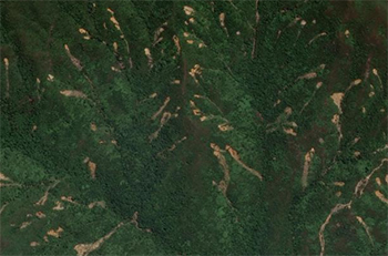
| …\Data\Train\Train_Image.png | Training image (from Google Earth) |
| …\Data\Train\Train_ID.txt | Landslide labels of the training image (different numbers denote different landslide instances) |
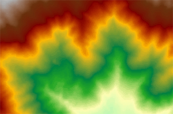
| …\Data\Train\Train_DTM.txt | Digital terrain model of the training image |
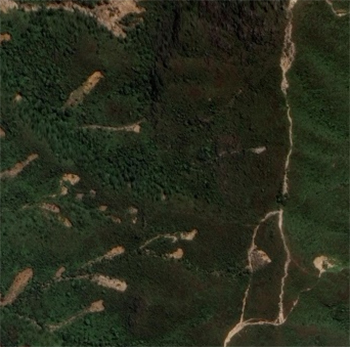
| …\Data\Test\Test_Image.png | Testing image (from Google Earth) |
| …\Data\Test\Test_ID.txt | Landslide labels of the testing image (different numbers denote different landslide instances) |
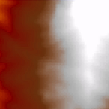
| …\Data\Test\Test_DTM.txt | Digital terrain model of the testing image |
Other figures (e.g., Train_ID.png, Train_Label.png) are provided for reference purpose.
 |
.jpg) |
 |
||
| Train_Image.png | Train_ID.txt | Train_DTM.txt | ||
 |
 |
 |
||
| Test_Image.png | Test_ID.txt | Test_DTM.txt |
 |
Requirements |
The participants in the Student Contest session are required to:
(1) Form contest teams (no more than four persons for each team; academic staffs are not allowed) and submit the participation form to Dr. Te Xiao (xiaote@sjtu.edu.cn).
(2) Submit an extended abstract in English (it will not be formally published) through the conference website; and submit computer codes used in the contest, as well as a presentation file that summarizes the obtained results, to Dr. Te Xiao (xiaote@sjtu.edu.cn).
(3) (For invited teams) Present results in English during the session (tentatively 10 minutes presentation plus 5 minutes Q&A).
The participation form and abstract template can be downloaded from the conference website https://www.fomlig2024.com/
 |
Evaluation criteria |
The three best teams will be selected by the Contest Organization Committee according to:
(1) The completeness of two tasks.
(2) The performance of the landslide detection model. The IoU (Intersection over Union) scores for object detection on both training and testing datasets should be provided for comparison. Note that the following two cases should be considered as false predictions: (i) dividing a single landslide instance into several landslide instances; and (ii) lumping several landslide instances as one landslide instance.
(3) The method used for uncertainty quantification. The teams able to properly deal with the uncertainty from “imperfect labels” will be ranked higher.
(4) The quality of the abstract writing and presentation.
 |
References |
Students are encouraged to read the following references to understand the challenge of this student contest. These references are meant to provide a flavor of the question and challenge. Students are not expected to apply the techniques in the papers.
| [1] | Fu, R., He, J., Liu, G., Li, W., Mao, J., He, M., & Lin, Y. (2022). Fast seismic landslide detection based on improved mask R-CNN. Remote Sensing, 14(16), 3928. |
| [2] | Ghorbanzadeh, O., Xu, Y., Ghamisi, P., Kopp, M., & Kreil, D. (2022). Landslide4Sense: Reference benchmark data and deep learning models for landslide detection. IEEE Transactions on Geoscience and Remote Sensing, 60, 5633017. |
| [3] | He, K., Gkioxari, G., Dollár, P., & Girshick, R. (2017). Mask R-CNN. In Proceedings of the IEEE International Conference on Computer Vision. pp. 2961-2969. |
| [4] | Meena, S. R., Soares, L. P., Grohmann, C. H., Van Westen, C., Bhuyan, K., Singh, R. P., Floris, M., & Catani, F. (2022). Landslide detection in the Himalayas using machine learning algorithms and U-Net. Landslides, 19(5), 1209-1229. |
| [5] | Shi, W., Zhang, M., Ke, H., Fang, X., Zhan, Z., & Chen, S. (2020). Landslide recognition by deep convolutional neural network and change detection. IEEE Transactions on Geoscience and Remote Sensing, 59(6), 4654-4672. |
| [6] | Su, Z., Chow, J. K., Tan, P. S., Wu, J., Ho, Y. K., & Wang, Y. H. (2021). Deep convolutional neural network–based pixel-wise landslide inventory mapping. Landslides, 18, 1421-1443. |
 |
Important dates |
| June 1, 2024 | | | Release of the question (Interested applicants should submit the participation form by June 30, 2024) |
| August 31, 2024 | | | Submission of extended abstract, computer codes and presentation file |
| Early September | | | Announcement of the invited teams |
| October 12, 2024 (Afternoon) | | | ISSMGE TC304/TC309 Student Contest |
| October 12, 2024 (Evening) | | | Award Ceremony |
 |
Organization Committee |
| Iason Papaioannou | | | Chair, Technical University of Munich |
| Jinhui Li | | | Harbin Institute of Technology (Shenzhen) |
| Ronald Schneider | | | Bundesanstalt für Materialforschung und -prüfung (BAM), Berlin |
| Te Xiao | | | Shanghai Jiao Tong University |
If you have any questions, please contact Dr. Te Xiao (xiaote@sjtu.edu.cn).
Please download the 8th ISSMGE TC304-TC309 Student Contest - Participation form here.